Fra Mauro's Mappamondo, a monument of late medieval cartography
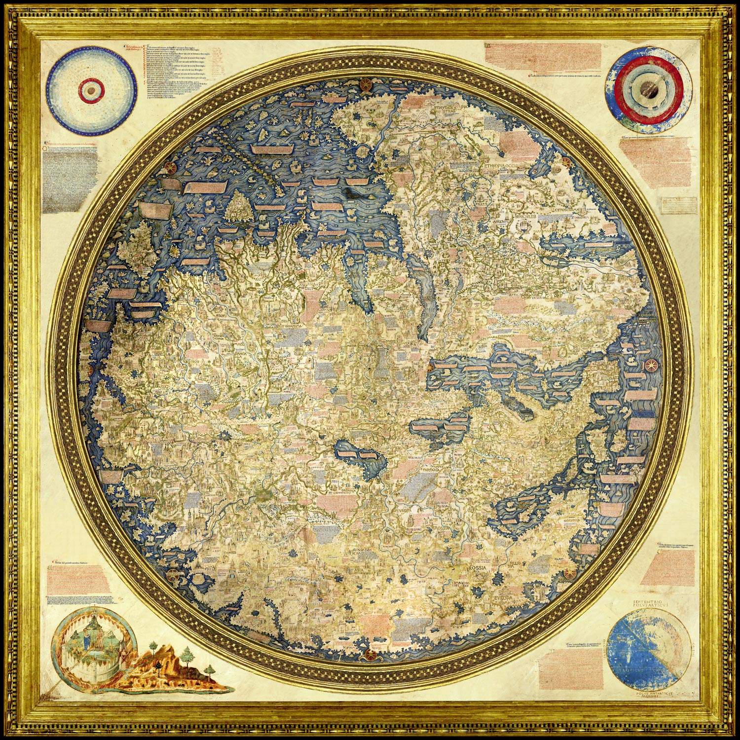
A work considered to be among the principal monuments of late medieval cartography can be found at the Biblioteca Nazionale Marciana in Venice: the Mappamondo di Fra Mauro, a large planisphere dating from the mid-15th century and attributed to the Venetian monk known, precisely, as Fra Mauro. The work represents theecumene, or the entire world with the lands known at the time of its creation.
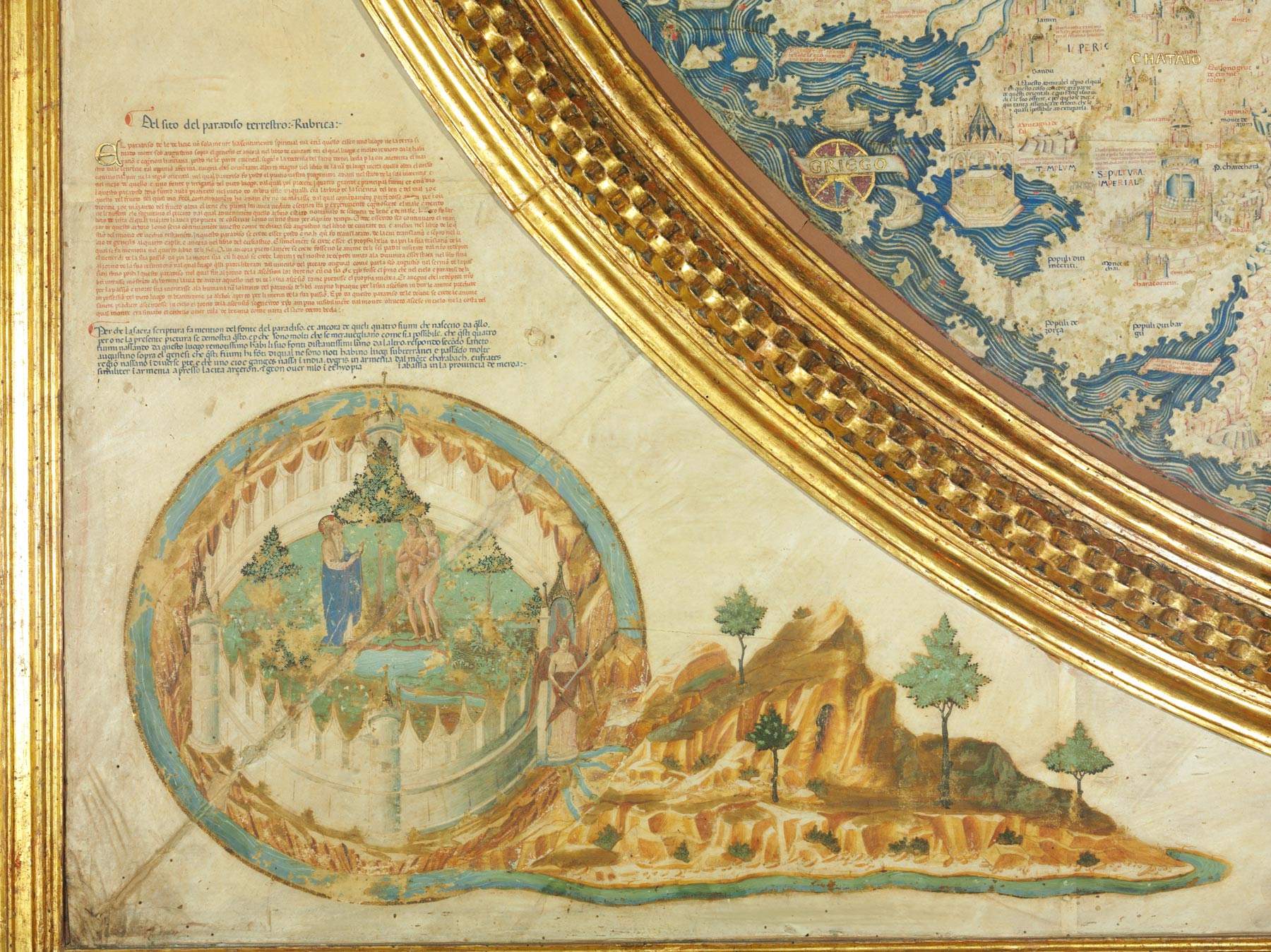
The Mappamondo is presented in an almost perfectly round shape (measuring 193 by 196 centimeters along the north-south and west-east axes), is composed of four calfskin scrolls, of which the joints can be glimpsed (at the Dardanelles, between India first and Chremania and finally through Sumatra), mounted on three planks of poplar wood perpendicular to the orientation of the scrolls. In Fra Mauro’s Mappamondo, the ecumene appears to be completely surrounded by seas, with a drawing oriented to the south. In addition, the representation lacks coordinates, scale and rhumb lines (those connecting the poles), but has the names of the cardinal points and intermediates in the margins. The work is then set in a square wooden frame measuring 223 by 223 centimeters, in the corners of which are cosmological notes: in the upper left corner (the geographical southeast) the number of heavens and astronomical distances, in the upper right corner (southwest) the theory of the tides and the theory of the landmasses, in the lower left corner (northeast) the description of the Earthly Paradise, with a depiction attributed to Leonardo Bellini, and finally in the lower right corner (northwest) the theory of the elements and the theory of the habitability of the Australian regions. Fra Mauro’s ecumene extends south from the southern limits of Africa, east from Java, west from the island of Madeira, and north from the northernmost part of the Permia region, which lies beyond the Ural Mountains. Hundreds of inscriptions (nearly three thousand) appear on the surface of the ecumene, which include place names but also historical and geographical notes that are essential for understanding the work as well as the mentality of the time and for realizing what geographical knowledge was in the 15th century.
Indeed, in medieval and late medieval depictions of the ecumene, the insistence on religioussymbolism was evident: the city of Jerusalem was located at the geometric and symbolic center of the depictions, and the Earthly Paradise was depicted within the drawing; Mauro, on the other hand, placed the Earthly Paradise outside the circle of the ecumene, to depict its symbolic and actual existence, according to the Augustinian doctrine referred to in the caption, but related to cosmographic space and not to chorographic space. The center of the then known world is placed in an area between Chaldea, Syria, and Mesopotamia. The choice of no longer considering Jerusalem as theaxis mundi, which might seem normal today but which Mauro himself had to judge as perhaps too innovative for his contemporaries, is to some extent justified by him in the extensive caption accompanying its toponym, with an explanation that evidently attempts to reconcile religious tradition and science: “it is in mezo de la terra habitabile secondo la latitudine de la terra habitabile, although according to longetudine la sia più occidental, but because la parte ch’è più occidental è più habitada per l’europa perhò l’è in mezo ancora secondo la longitudine. Not considering el spatio de la terra but the multitude of habitants.” In the Mappamondo, moreover, very rare references to biblical texts appear. For example, there are conventional references there for Mount Horeb, or Babylon, or a note with the supposed derivation of Africa’s name from a descendant of Abraham, plus there are only three references to saints: under Patras is reported “qui fo marturizà sancto andrea apostolo,” in the sea between Cyprus and Cilicia, in a cartouche, we read “In questa cita de tarso naque san paulo apostolo,” and finally within a cartouche west of the Norwegian coast is the note “...Qui se dice esser el corpo de sancta brigida la quale segondo alguni fo de suetia ...”.
We do not have much information about the author of such a complex work: we do know that Fra Mauro was certainly a converso of the Camaldolese monastery of San Michele di Murano, where he carried out his trade as a cartographer, so much so that he had an atelier around him, since several collaborators certainly had to take part in the creation of a work as complex in content and demanding in form as the Mappamondo now at the Marciana. However, we know the names of just two of them, thanks to the evidence obtained from the convent’s expense records: in 1457, and again in 1459, Francesco da Cherso, a monk at San Michele, was called, and in 1459 Andrea Bianco, a galley commander and important cartographer, author of a well-known nautical chart dated 1448 and preserved at the Biblioteca Ambrosiana in Milan. The work of the Camaldolese converso thus took place within this time frame and before August 1460, that is, before the date given in an inscription on the back of the wooden support of the globe, “MCCCCCCLX adi XXVI avost. Fo chonplido this work.”
The preparatory work of the Mappamondo was certainly long and thorough. We can realize this by observing not only the richness and detail of the cartographic description, but also the contents of the numerous notes and descriptions accompanying the recorded place names. The treatment and number of sources used certainly constitute the greatest gap between the representation of the world made by Mauro and earlier cartography. Fra Mauro’s Mappamondo, an extraordinarily innovative work for its time, in fact encompasses a very varied synthesis of different languages (cartographic, historical, literary, oral testimonies).
The illustrated space is represented by images and texts: the images take up a typology common to previous cartography (mountains, rivers, palaces, temples, churches and mosques, bridges, sepulchral monuments, ships, animals, plants are noted), and furthermore reproduce rather conventional stylistic features, while the texts offer descriptions and discursive explanations, in which the author’s desire to make explicit his choices and the reasons behind them can be clearly grasped. In these notes, all drafted in the Venetian vernacular, the author has introduced news, observations, comments and reflections, which hint at a sure knowledge of the writings of classical, late Latin and early medieval authors that are quoted and thus provide the coordinates of Fra Mauro’s geographical knowledge: Aristotle, Ptolemy, Strabo, Cato, Statius, Pliny, Messalla, Arrian, Arrianus, Sallust, Pomponius Mela, Solinus, St. Jerome, St. Augustine, Albertus Magnus, St. Thomas Aquinas, and Nicolas de Lyra. The author also demonstrates a great familiarity with strictly cartographic material, for example, portolans (maps where ports were marked) and nautical charts in general, and with less conventional sources, such as the travel accounts of merchants, missionaries, and navigators. The awareness of the importance of the work that Mauro was producing, as well as its novelty compared to previous representations of the ecumene, finds a synthesis in a cartouche placed on the south side of Brittany, where Fra Mauro explicitly declares that he wanted to address a wide audience without, however, excluding the literati. Indeed, one reads, “In this work by necessity I have conuenuto usar modern names and uulgari. because al uero se io hauesse fato altramente. pochi me haueria inteso saluo che qualche literato. auegna che ancora lor non possa acordar hi autori. cum quel che hora se pratica.”
Of the almost three thousand surviving inscriptions, to which should be added all those related to the area of Venice and the upper Adriatic, northern and central Italy, which are almost completely worn out, as many as 309 contain, in more or less extensive form, notations that, as anticipated, are not limited to toponymy. Many of these notes are presented in summary form: at the Gulf of Mannar, for example, we read “In this colf se pesca perle,” or again in a note south of Aden, “Qui se paga el datio,” while others are articulated over several lines of text. A legend is placed at the edge of the Septentrion, a kind of warning to the reader that is of particular interest not only because it suggests that the Planisphere may have been made on the commission of the Serenissima itself (“Questa opera fatta a contemplation de questa illustrissima signoria non ha in sì that fulfillment that doueria because it is certainly not possible to l’intellecto human ...”), and because it takes up the theme of the limits of Ptolemy’s work (“intendando lui non hauer possudo in tuto uerificar la sua cosmographia”), but above all because it declares its intentions in a resolute manner: “Per tanto dico che io nel tempo mio ho solicitado uerificar la scriptura cum la experientia inuestigando per molti anni e praticando cum persone degne de fede le quali hano ueduto ad ochio quello che qui suso fedelmente demostro.”
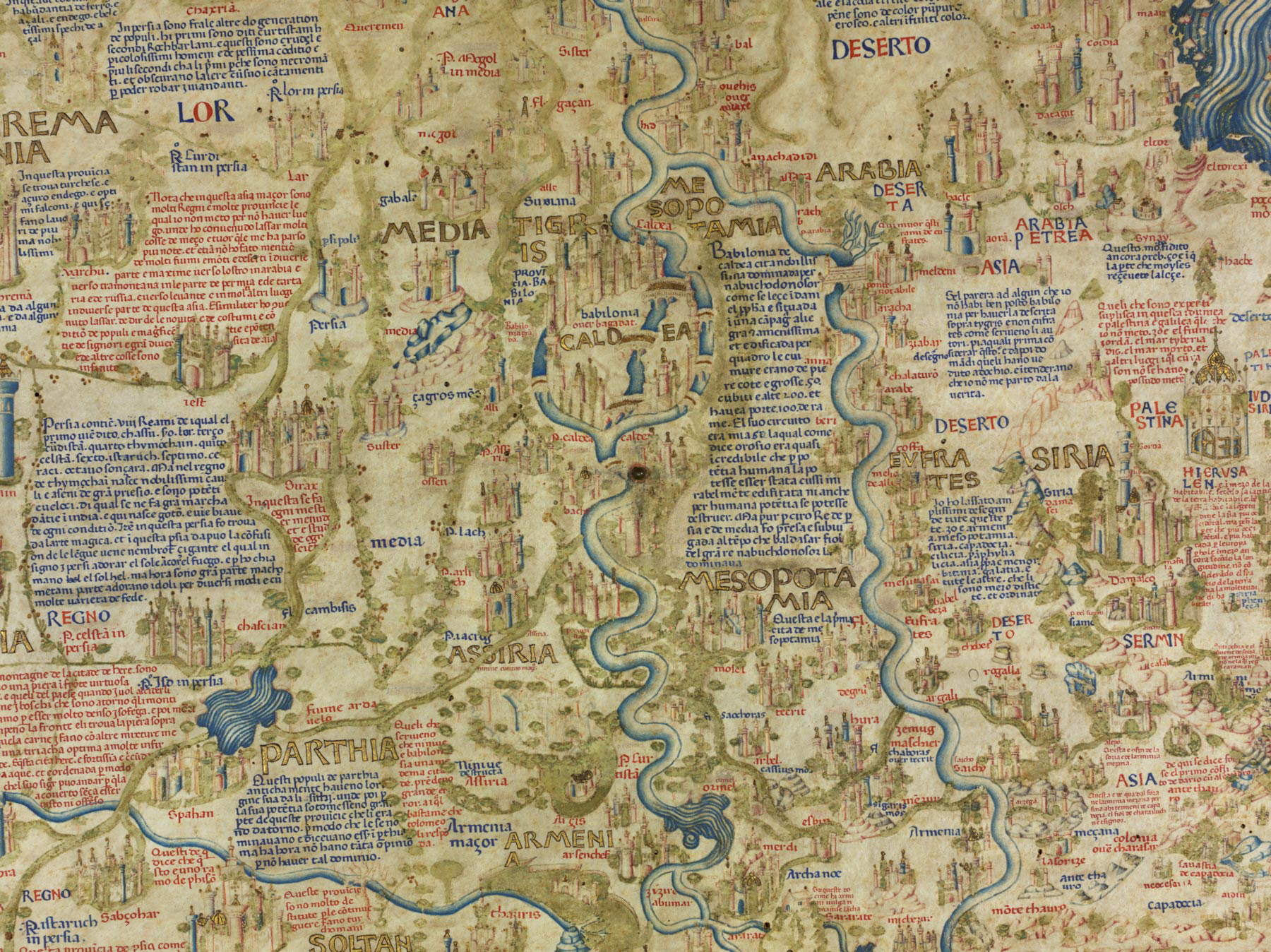
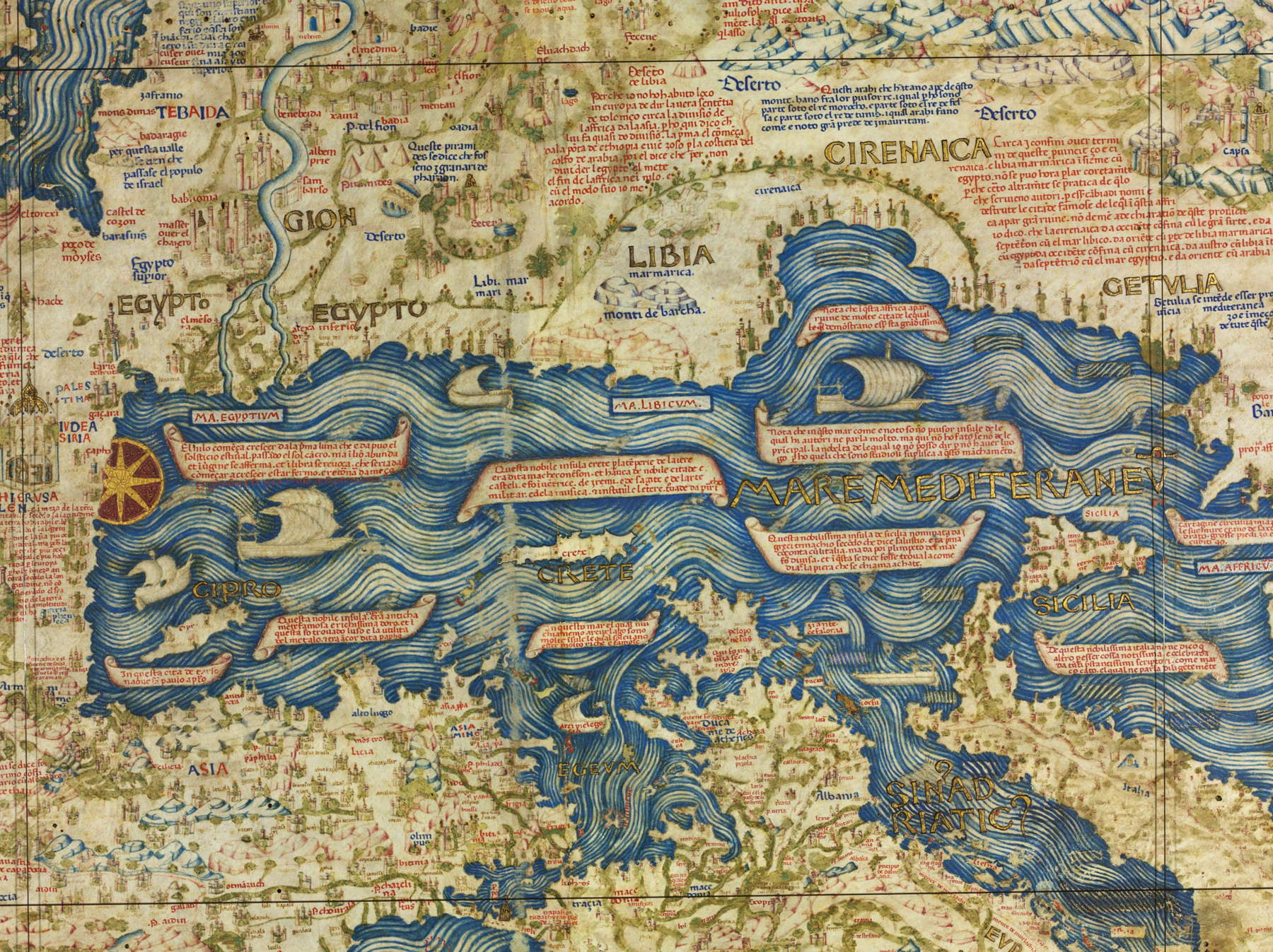
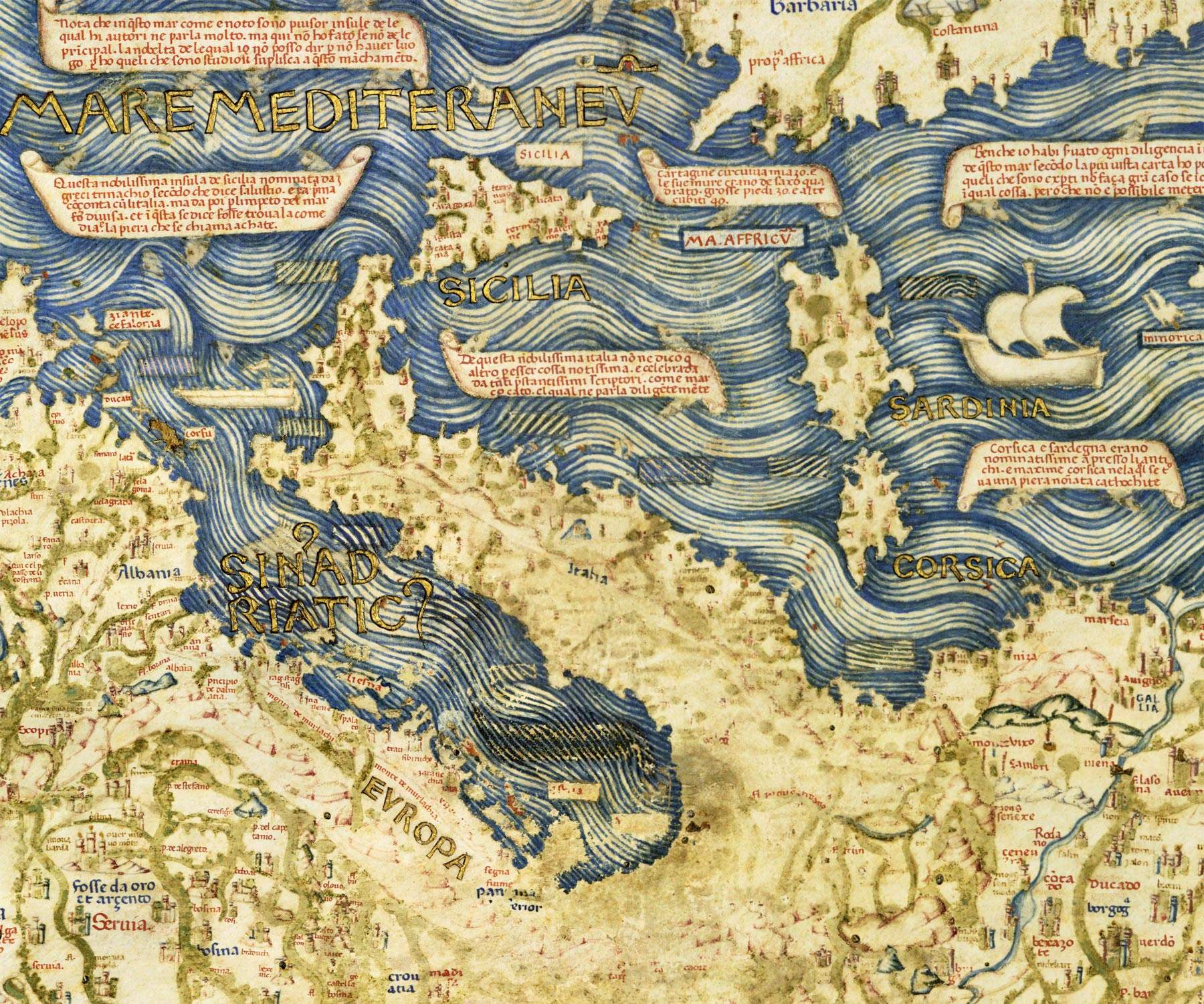
The very modern attitude with which Mauro deals with auctoritates in historical and chorographic studies (“molti cosmographi e doctissimi homeni i quali scriveno che in questa Affrica, maxime ne le Mauritanie, esservi molti monstruosi homeni e animali”) shows how the author of the Mappamondo was already oriented towardscientific observation, expressed in the “diligentia” with which the author gathered information and evidence. This modern projection of the study and representation of geographical space contrasts with the fact that his indebtedness to Marco Polo’s work is completely overlooked, perhaps because from reading the place names and cartouches, the Polean texts emerge so clearly that Fra Mauro considers the references superfluous. In fact, in the mid-15th century, those who wanted information about Asia still had to draw on the Milione, which still at that time, despite the two-century gap, was still an indispensable text for a chorographic description of the Asian continent, although Fra Mauro had enriched the Mappamondo with recent news, evidently gleaned from the many travelers and merchants, who were then arriving in Venice, then a reference to which everyone looked and through which the obligatory junction in trade between East and West took place.
The fortune of Fra Mauro’s Mappamondo as a graphic representation of a cognitive model is attested as early as the 16th century, in small part in Giovanni Battista Ramusio, but more so in Agostino Fortunio, and it knew revivals and testimonies since its creation. The work was originally placed in the church of the monastery of St. Michael, was then moved to an adjoining room, then known precisely as the Mappamondo, and finally transferred to the monastery library on January 20, 1655, as recorded in a parchment scroll pasted in the upper right part of the wooden frame, under the cosmological note of the theory of the tides. The library of the convent of San Michele suffered the same vicissitudes as the convent libraries during the Napoleonic domination, and then the religious suppressions, and it was thanks to Jacopo Morelli (director of the Marciana from 1797 to 1819) that the Mappamondo was transferred to the Marciana in May 1811. As of 2022, having completed the design work in the new layout of the museum itinerary, which includes in addition to the Monumental Rooms the reduced rooms of the Procurators of St. Mark’s, this cartographic masterpiece can be seen in a context that enhances its formal beauty and allows for a better reading through high-definition reproduction (of the globe and the frame), reworked in two scientific projects, one curated by the Galileo Museum in Florence and the other by Nanyang Technological University in Singapore.
The Marciana National Library
The first nucleus of the Biblioteca Nazionale Marciana dates back to 1468: in fact, the Venetian institute owes its birth to the patronage of Cardinal Bessarione, who that year donated to Venice his collection consisting of about 750 codices, to which he later added another 250 manuscripts and some printed works. Only several years later did the Venetian Republic decide to have a palace built to house Bessarion’s collection and at the same time become the public library of the Venetian state: the construction of the building was entrusted in 1537 to Jacopo Sansovino (Florence, 1486 - Venice, 1570), who had the first sixteen arches erected, while Vincenzo Scamozzi (Vicenza, 1548 - Venice, 1616) continued the work in 1588 by demolishing the Palazzo delle Beccherie and building the last five arches toward the pier.
Preceding the entrance to the Libreria di San Marco is the vestibule, where Titian Vecellio ’s painting of Wisdom introduces the Salone. Two important decorative cycles were made for this room: for the walls, portraits of philosophers by Paolo Veronese, Jacopo Tintoretto and others, and for the ceiling, roundels depicting the arts and virtues by Andrea Schiavone, Paolo Veronese, Battista Zelotti, Giulio Licinio, Battista Franco, Giuseppe Salviati and Giovanni De Mio. The Marciana soon increased its collections mainly thanks to donations and bequests, including those of the physician and botanist Melchiorre Guilandino (1520-1589), the surgeon Girolamo Fabrici Acquapendente (1533-1619), Giacomo Contarini (1536-1595), and from the’beginning of the seventeenth century, as a result of the obligation imposed on printers to deposit there a copy of every book published, as required by a Venetian law of 1603 (the first in Italy on the subject), it also began to preserve all the editorial production of the numerous and flourishing printing houses active in the territories of the Serenissima. At the beginning of the 18th century its book holdings numbered around ten thousand volumes, and other important donations increased its value: the bequest of the bibliophile Giambattista Recanati (1687-1724), that of the scholar and translator Tommaso Giuseppe Farsetti (1720-1791), and that of the collector Giacomo Nani (1725-1797). After the fall of the Venetian Republic, the library was enriched as a result of the concentration in it of part of the libraries of religious bodies suppressed in the Napoleonic era, but donations from private individuals continued.
Today the Marciana holds 13,117 manuscripts and about one million printed books including 2,887 incunabula and 24,000 cinquecentine. In addition to its important holdings of Greek, Latin and Italian codices, the Marciana preserves more than 22,000 printed music editions, including numerous Venetian editions from the 16th-17th centuries (from Gardano to Girolamo Scoto and Alessandro Vincenti) but especially 19th-century scores that have come by right of printing. Always oriented towards the preservation, growth and enhancement of its historical collections, the Marciana has been able to grasp, already at the end of the 1990s, the importance of the diffusion of the consultability of its manuscript and printed heritage to an ever wider public, carrying out important digitization projects that allow its use on the web.

Warning: the translation into English of the original Italian article was created using automatic tools. We undertake to review all articles, but we do not guarantee the total absence of inaccuracies in the translation due to the program. You can find the original by clicking on the ITA button. If you find any mistake,please contact us.


