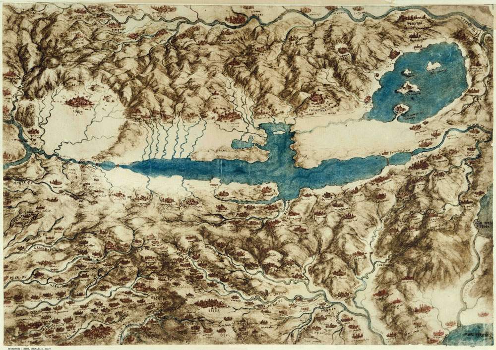
Opening May 25, 2019, at the Montepulciano Fortress is the exhibition Leonardo in Valdichiana: the drawing of the territory and the science of water, open to the public until September 8, 2019.
It is in fact Leonardo da Vinci ’s Map of the Valdichiana (Windsor, RL, 12278), one of his finest cartographic works: in fact, the great Tuscan genius was also a cartographer and there are numerous maps drawn by him. The Map of the Valdichiana was made between 1502 and 1503, during the period when Leonardo was in the service of Cesare Borgia as architect and military engineer. One of the most famous maps characterized by its rich topographical and hydrographic content and bird ’s eye view representation similar to an aerial photograph.
It also turns out to be almost three-dimensional, thanks to the perspective with which the artist depicted the castles and mountain ranges and the flattening of the Volterra territory. The place names make it possible to identify 254 geographic locations, including towns, castles and rivers, spread over an extensive territory between Florence, Aretino, Trasimeno, Sienese Chianti, Volterrano, Val d’Orcia and Val di Cecina.
Evident is the large swampy area of the Valdichiana: Leonardo depicted the marshy area with a light blue in order to make visible, using a darker blue, the many streams that flowed into the master canal of the Chiana, the ancient river Clanis from which the region derives its name.
In a study sheet (Windsor, RL, 12277) the hydrographic function of the map is clearly noted: Leonardo had surveyed a dry canal here, noting that it was closed by the lord of Perugia, Andrea Fortebracci. The latter’s closure was one of a series of attempts to reclaim the Valdichiana that continued until the eighteenth century.
Presumably Leonardo’s Map was meant to serve as a preliminary study to a decisive reclamation of the Chiane territory. Or else the hydrographic study of that territory was to be used to transform the unhealthy marshland into a large water reservoir to ensure the constant navigability of the Florence Canal, a project that the genius drew up in the same period for the Florentine Republic. Following this second hypothesis, the Map of the Valdichiana ties in with the other maps of the Tuscan territory, in which Leonardo elaborates the project of the navigable canal from Florence to the sea. These include the maps of the Valdinievole and Valdarno Inferiore (Windsor, RL 12685), where a pencil mark traces the route of the canal from Florence, passing through Prato, Pistoia, Serravalle and the Padule di Fucecchio, would have reached the sea at Pisa, or near Livorno.
In addition, a note in the Codex Atlanticus reads “Facciasi alle Chiane di Arezzo tali cateratte che mancando acqua la state in Arno il canale non rimanere arido”: evidence of the link between the reclamation of the Valdichiana and the navigable canal.
For info: www.leonardomontepulciano.it
Hours: Daily from 10:30 a.m. to 7:30 p.m.
Ticket: 5 euros.
Image: Leonardo da Vinci, Map of the Valdichiana (c. 1503; Windsor, Royal Collection)
 |
| Leonardo was also a cartographer. In Montepulciano an exhibition around the map of Valdichiana. |
Warning: the translation into English of the original Italian article was created using automatic tools. We undertake to review all articles, but we do not guarantee the total absence of inaccuracies in the translation due to the program. You can find the original by clicking on the ITA button. If you find any mistake,please contact us.