Sardinia, a nuraghe discovered thanks to laser technology investigating sites covered by vegetation
As part of the Nuraghe project, which emerged as the winner of the 2021 national call for access to the mobile laboratories of E-RIHS.it, the Italian node of the European Research Infrastructure for Heritage Science, coordinated by Costanza Miliani, director of the CNR-Ispc, LiDAR (Laser Imaging Detection and Ranging) technology for the investigation of archaeological sites covered by vegetation was fielded. A technology that allows archaeological structures and topographical variations of cultural interest to be unearthed that are unknown or partially known due to the great difficulty of surveying them from the ground.
LiDAR from drones is currently used by the AirLab research laboratory, directed by Nicola Masini, research executive of the Cnr-Ispc in Potenza: a platform on drones for the acquisition of remote sensing data with active and passive sensors, part of the MOLAB aerial platform, funded by the Ministry of University and Research (MUR) through the PON Research and Innovation 2014-2020 action aimed at strengthening research infrastructures, with the SHINE project.
Thanks to the facilities and expertise of the CNR-Ispc, the nuragic site of Bruncu ’e s’Omu in the territory of Villa Verde, in the province of Oristano, was investigated, in which Riccardo Cicilloni, a professor of prehistory and protohistory at the University of Cagliari, has been conducting research and excavations since 2013 thanks to an excavation concession from the Ministry of Culture and the logistical and financial support of the Municipality of Villa Verde. The site is located in a predominantly volcanic area, in which archaeological research has shown that the area was intensively populated during the Bronze and Iron Ages (18th-8th centuries B.C.) by numerous Nuragic sites. Prominent among them is the site of Bruncu ’e s’Omu, characterized by a monumental Nuraghe and a hut settlement from the Final Bronze Age period (1150-900 BC), now being excavated by the University of Cagliari.
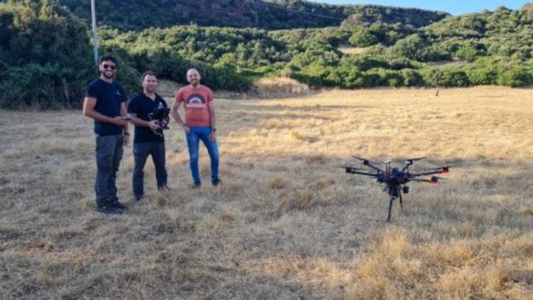
The objective of the LiDAR surveys, supplemented with multispectral and thermal infrared prospecting by drone, was to broaden the field of investigation in a densely forested area that is otherwise difficult to investigate by traditional reconnaissance and topographic survey methods. Performed with a high density of points, appropriately processed by automatic extraction procedures, including machine learning techniques, the LiDAR drone surveys revealed numerous topographic and micro-topographic variations. The data obtained, combined with ground reconnaissance, were found to be of considerable archaeological interest. Prominent among them are the ruins of a Nuraghe and the structures of two hut settlements.
“The extraordinary and unexpected discovery highlights, on the one hand, the great potential of LiDAR on drone, which for the first time has been applied in Nuragic contexts, and on the other hand, it broadens the area of investigation, posing new questions about the function and importance of the Bruncu ’e s’Omu site,” explains Nicola Masini. “An important aspect of LIDAR,” he continues, “is the processing and classification of point clouds especially in contexts, such as the Nuragic one, characterized by dense vegetation to be digitally ’removed’ in order to visualize microtopographic variations for its effective archaeological interpretation.”
“By means of automatic data enhancement and extraction procedures, integrated with classical archaeological reconnaissance activities, the right balance between the need to reduce ’noise’ and the need to emphasize microtopographical features of archaeological interest has been achieved,” added Nicodemo Abate, research fellow of the E-RIHS.it node at the CNR-Ispc in Potenza, thanks to funding from the MUR for strengthening the human capital of research infrastructures.
“The collaboration between the University of Cagliari and Cnr-Ispc,” stresses Riccardo Cicilloni, head of excavation activities, "has proved invaluable and a harbinger of great novelties, both from the methodological point of view and from the applied research point of view, with the discovery of unpublished and important Bronze Age sites.
"The discovery of the unpublished structures at the Bronze Age site of Bruncu ’e s’Omu was made possible through the use of MOLAB, the mobile laboratories of the Research Infrastructure for Heritage Sciences, which, led by the CNR with an open access model for the national and international scientific community, promotes interdisciplinary research in which the most innovative investigation methodologies are employed for basic and applied research for the knowledge, protection and enhancement of cultural heritage," concluded Costanza Miliani, director of the CNR-Ispc and coordinator of the Italian E-RIHS node.en.
Image: Some members of the AirLab CNR ISPC team: (from left) Nicodemo Abate, Valentino Vitale and Antonio Minervino Amodio | © AirLab CNR ISPC
 |
| Sardinia, a nuraghe discovered thanks to laser technology investigating sites covered by vegetation |
Warning: the translation into English of the original Italian article was created using automatic tools. We undertake to review all articles, but we do not guarantee the total absence of inaccuracies in the translation due to the program. You can find the original by clicking on the ITA button. If you find any mistake,please contact us.


